 Buy Walking Videos
A handy online pedometer
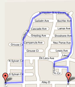 If you’re planning a walk or bike ride around your neighborhood, you might find this useful. Gmaps Pedometer uses Google Maps to measure a route you enter on the map.
It defaults to Hoboken, New Jersey, so you’ll need to start with the “if you don’t live in Hoboken” link, or just start here. Use the zoom control and drag and drop to find your location—for example, here’s Salt Lake City. Click Start Recording and double-click several points along the route, and the total mileage of the entire route is displayed.
With a bit of practice you can get a pretty complicated route onto the map. Use the Permalink feature to save your route to your favorites or email it to someone. There is other software out there for this purpose, but this one’s free, and you can’t beat the accuracy of Google Maps.
Previous: FDA Clears Syneron VelaSmooth for Cellulite Treatment
Next: Atkins Was Partly Right: Protein Makes Me Feel Full
July 19th, 2005 at 12:26 pm
And it appears to work on any area of the map too, not just roads. So, if you wanted to know how far you travelled on the river, it will tell you that too. Unfortunately the Google map doesn’t detail the section of river I travelled. To get around that problem, I switched to the sattelite view, which shows the river section I travelled. And I was able to plot the points right on the satellite image. Pretty cool.
March 27th, 2007 at 10:35 am
This is great! Thanks for the info I used the map and the satellite view and it helped. I was able to see the path along the beach that we walked on.